 Accommodation | International
Flights | Domestic
Flights | Tours
| Travel
Insurance | Car
Hire | Visas
| Shopping
| Dating
| Humour
Accommodation | International
Flights | Domestic
Flights | Tours
| Travel
Insurance | Car
Hire | Visas
| Shopping
| Dating
| HumourAbout Cape Tribulation - Accommodation - Tours & what to do - Transport & car hire - Photos - Map
Cape Tribulation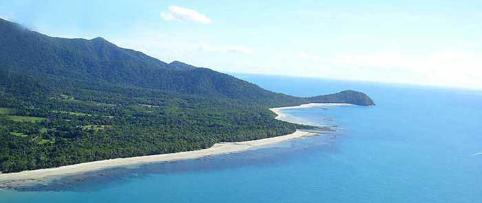
Cape Tribulation is situated 36km. north of the Daintree river in the Daintree National Park, about 150km. north of Cairns, the nearest international airport.
Once you arrive in Cape Tribulation it will not take you long to see why this place has become so famous, this is where the World Heritage listed living museum of the oldest rainforest in the world meets golden beaches and the colorful coral and fish of the Great Barrier Reef.
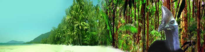
This is one of the very few places in the world where you can actually come face to face with a cassowary, these endangered giant ancient birds still roam the forests and while hiking you can encounter them.
Many Cape Tribulation accommodation places give you a chance to actually stay inside this ancient forest and tour operators offer you a variety of tours to explore these natural wonders, including guided rainforest walks, snorkeling and scuba diving on the Great Barrier Reef, sea kayaking, jungle surfing, exotic fruit tasting, crocodile spotting, etc.
No wonder the motto of the local tourism association is; You need to stay more than a day.
Find what you need in Cape Tribulation here with
one click !
ONLINE
TOURBOOKINGS IN CAPE TRIBULATION - ONLINE
ACCOMMODATION BOOKINGS IN CAPE TRIBULATION
Dutch travellers, click here for a Dutch language travelguide to Cape Tribulation
You might get a bit bored with reading this slogan while you do
your research on Cape Tribulation but it is true;
the rainforest really does meet the reef here !
Cape Tribulation has a colorful history, it was known as Kulki by Aborigines for thousands of years and renamed Cape Tribulation by James Cook as this was the place where his tribulations (trouble) began. Then in the 1970's hippies discovered the place, followed by tourists and nowadays the tiny but worldfamous town of Cape Tribulation is in the top 10 of well known tourist destinations in Australia, known as "Where the rainforest meets the reef".
'Cape Tribulation' and 'the Daintree' are two terms
used to describe the area north of the Daintree River. If you
want to see the oldest rainforest in the world you will have to
cross the Daintree river.
You can do a detour to Daintree Village south of the river, it
is a scenic drive and there are some accommodation places and
wildllife tours but do not expect this to be the village in the
rainforest. All the trees around here were cut down over a hundred
years ago, in their timber museum you can see old black and white
photos of the huge red cedar trees that were cut here.
Too many people only travel up to Cape Tribulation from Cairns and Port Douglas on day trips, this means you will spend six hours just in driving time, not leaving much time to actually see and fully experience this unique place. Surveys have found that a lot of daytrippers were not all that satisfied with their day. If you are running out of holiday time and simply can not afford more than a day before you have to go home, click here for more info on a day trip . Seeing it in a day is still better than not at all and it probably will convince you to return in the future for a longer stay.
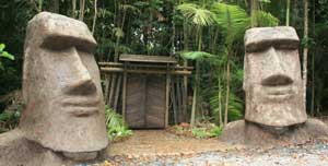
Don't miss the Easter Island Moai and the sculpture trail at Rainforest
Hideaway
When you're in Cape Tribulation you might also like to have a look at the Easter Island Moai, find them at Rainforest Hideaway on Camelot Close, signposted from the main road, right in the heart of Cape Tribulation. There is also a rainforest sculpture trail to explore here, which makes this probably the most unique Daintree accommmodation !
You may be lucky enough to spot a cassowary, up to two metres tall, covered in coarse black double stranded feathers, and with brilliant colors of red and blue on its neck and head this would have to be Australia's most spectacular bird. They are highly endangered and live only in the Wet Tropics area of North Queensland, another patch of remote rainforest high up on the Cape York peninsula, and New Guinea. More info on cassowaries... |
Cassowaries growing up around Rainforest Hideaway B&B |
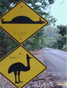
Once you have crossed the Daintree River on the ferry please keep your speed down, these birds can cross the road very unexpectedly and a collision with one of those birds would be disastrous, both for the bird and the local eco-system, your rental car and your wallet, and not to mention the risk of getting lynched by greenies! The sign on the left shows a bit of creativity by local midnight artists, it looks like even the local council has a sense of humour as this graffiti has been here for years now. |
 |
When to go:
Any time of year has its attractions. Most people come in July and
August, these are the coolest (even cold) months and officially the
dry season, but it is also often a windy time of year. From September
onwards you have a better chance of good conditions to go out to the
Barrier reef, go sea kayaking and of course
good weather for the beach to do your lazing and sunbathing. Late November
the box jelly fish start coming around so swimming at the beach is not
recommended but the sunny and calm conditions are usually perfect for
sea kayaking and Great Barrier Reef trips
( there are no box jelly fish out at the reef).
In December it starts getting hotter and with a bit of luck there
will be some showers to cool things down. January is usually still
a dry month with high temperatures. February and March are the
official wet season, but in recent years it quite often remained
beautiful weather through these months, though the town was still
abandoned by tourists, this is the time of year when you can get
some great standby
rates on accommodation. A normal wet season can be
an awesome experience, it is simply unbelievable how much water
can fall down, the rainforest looks its best and the creeks and
waterfalls are roaring. April and May are a bit harder to predict,
they can be dry or they can have showers throughout these months.
June is usually cooling down and drying up.
A brief history of Cape Tribulation;
Aborigines - For many thousands of years, the Kuku Yalangi Aboriginal people lived along this coastline, foraging for rainforest fruits and hunting the rainforest animals, there is no evidence they ever permanently lived in Cape Tribulation but they used to camp here at times and travel back and forth between Mossman (70 km. south) and Wujul Wujul, (35 km. north). This was why there was already a well used track from Cape Tribulation to the Bloomfield River when white settlers arrived in the area. Some of the earliest settlers, the Masons, who lived just north of the cape where now the parking area for Cape Tribulation beach is, frequently had Aborigines passing by their kitchen window as they had, without knowing, built their house on an Aboriginal road. As early as the 1880s timber cutters called had already used this track to search for red cedar. For a while the cassowaries seemed to have disappeared but in recent years they have made a comeback in Cape Tribulation.
James Cook - The next chapter in the history of Cape Tribulation is James Cook. He had been sent out from England to Tahiti to observe Venus passing in front of the sun. Thanks to his measurements scientists could now work out the distance between the earth and the sun and a range of other things. But to justify the expense of the journey the British Crown had decided that he was also to take possession of New Holland to expand their empire. Cook sailed up the east coast and did quite a bit of surveying and drew up numerous charts, as so far he only had a fairly basic map from the Dutch explorers that had been here 160 years before him. Things ran fairly smoothly until one night after passing this area his ship struck the reef. The Endeavour came very close to sinking, luckily a large chunk of reef had broken off and remained in the hole and actually worked as a plug, this together with a sail covering the hole, the crew pumping like mad and the dumping of all non vital heavy things like cannons, they managed to keep the ship afloat. So when Cook looked out on the coast at first daylight he was not in the happiest of moods and named a few features with not the most cheerful of names; the cape he could see was named Cape Tribulation (tribulation means trouble) and the mountain behind it Mount Sorrow. The reef the ship had struck was named Endeavour Reef and a bay to the north where they rested while towing the ship up the coast with row boats was named Weary Bay. Finally they found a river to go up and beach the ship so it could be repaired, this one was then named the Endeavour River and that is where Cooktown is located nowadays. After seven weeks of repairs, some run-ins with Aborigines and discovering the kangaroo, they headed further north where they planted the Union Jack and officially took possession of this country. This makes the striking of the reef off the coast of Cape Tribulation all the more significant; had they sunk here they would not have been able to claim Australia later on and it could have still been New Holland nowadays. Cape Tribulation would look very different indeed with windmills instead of coconut trees along the beaches and coffee shops in the resorts instead of bars. And the moisture of the rainforest and the Australian termites would have made short work of the wooden clogs as well.
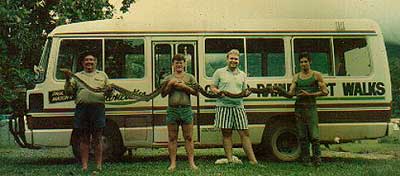
Paul and Lawrence Mason, one unknown and Jim Manning holding a python
at Cape Tribulation..
Photo courtesy of Mason's
Tours
Sub-divisions and hippies - In the 1970s Cape Tribulation was discovered by the hippies and it became the end of the London-Kathmandu-Cape Tribulation overland trail. Marijuana growing, smoking and running around naked on the beaches were the main activities during this decade. Cape Tribulation was also discovered by the property developers during this time. A few enterprising individuals with friends in the right corrupt government places took out large grazing leases, then converted to freehold, and then divided them into about 1200 smaller lots, in Cape Tribulation two hectares is the smallest size but in Cow bay there are many one hectare blocks. Though normally the developer has to provide services like power, water etc. this was all overlooked by the various government departments, who were either corrupt or incompetent or perhaps both. The local Douglas Shire Council opposed the subdivision but was overruled. A nationwide advertising campaign was started and people bought blocks of land for reasons that varied from preservation to intending to live there to investment as all power and water services were promised and many thought land values would skyrocket.
Declaration of National Park - In 1981 the rainforests surrounding the privately owned land were declared Cape Tribulation National Park, under protest from local council and state government who wanted to keep it as a State Forest, so it would be available for logging.
Blockade of the Bloomfield Track - Cape Tribulation really became famous when in 1982 the Douglas Shire Council began bulldozing a track north of Cape Tribulation in 1982. Protesters came from everywhere and tried to stop the road, leading to several arrests by the army of policemen. The protests were unsuccesful in stopping the bulldozing of the forest to clear a road but it did lead to the nomination and subsequent inclusion of the area on the World Heritage List because of the publicity surrounding the issue. The protest leader, Mike Berwick, stood for mayor of the council he protested against and won! He remained mayor for several terms until in 2008 a state wide council amalgamation meant that the Douglas Shire no longer existed and he had to look for another job. The amalgamation had been for the purpose of eleminating financially troubled shires but the State Government saw here the perfect opportunity to once and for all get rid of Berwick's dysfunctional council that had wasted so much time and money with inquiries over the years.
World Heritage Listing - In 1988 UNESCO declared Cape Tribulation National Park a World Heritage Area because of its outstanding value and beauty, once again local and state government protested to no avail.
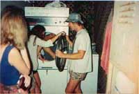
Backpackers - In 1985 the first backpackers hostel, the Jungle Lodge, was built. Cape Tribulation, in particular PK's, developed a reputation as a major backpacker party place amongst the young crowds that shag and drink their way around Australia. Highlights included drinking games, cane toad races, limbo competitions, beach bonfires, and spontaneous alcohol-inspired things like dryer riding (see pics).
 |
 |
Solar power subsidies - In 1996 the Queensland state government offered residents north of the Daintree river subsidy to install solar power. So far only mayor Mike Berwick and some neighbours were the only ones north of the Daintree river to enjoy mains electricity from a cable hanging over the river. The denial of mains power to others from the Daintree river to Cape Tribulation was deliberate to discourage settlement as this would lead to degradation of the fragile eco system of this area. During 1996 and 1997 many houses were fitted with solar panels, batteries and back-up generators. Most households run their generators a fair bit as solar power in a rainforest is not the ideal solution but it scored Australia points at the Kyoto Greenhouse Convention. Currently many residents are calling for "mini-grids", it would be far more efficient for a community like Cape Tribulation to have one big generator with a cable network for the town than thirty households run their own generator, this is not too difficult to organize, where ever there is a small Aboriginal community in the outback this system is used, but so far no results.
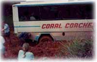
Flood - 1996 also saw some very wet weather, in february 1996 1500mm of rain (yes, one-and-a-half metre) of rain fell in 36 hours in the Daintree river catchment area and the river rose that high the cafe at the ferry crossing only had its roof sticking out of the water and the current was that strong that the ferry cables on the north side broke and the ferry would have washed out in to the ocean had it not been for the cables holding on the south side. When the water subsided again the ferry was sitting high and dry on the riverbank and it took a week to get it back in action again. Meanwhile the reef trip operator in Cape Tribulation used his boat to ferry tourists out to Port Douglas and food back up. You can see some more pics of awesome Cape Trib weather on our weather page.
| Completion of the road - In April 2002 the last section of road was sealed. It had taken the local council no less than TEN years to surface the 36 kilometres of road from the Daintree river ferry to Cape Tribulation. When you consider the 6700 km. long Great Wall of China was also built in ten years, at the rate of a mile a day, that does make you wonder about the productivity of the Douglas Shire Council employees a bit..... |
|
Development ban - In June 2004 the
Douglas Shire Council managed to severely upset a lot of people by announcing
a 12 month moratorium on all building and development permits, which
was also meant to become part of the town plan, turning it into a permanent
ban on all building. Many landowners that had not yet built suddenly
found their land worthless and were very upset. Mayor Mike Berwick has
three police men on his side when he came to a meeting to tell Daintree
residents how screwed they were. For nearly a year an enormous amount
of time and money went in to consultants, lawyers, meetings, planning
etc. and then it was voted out again in May 2005, then voted back in
and so the saga continued, much to the distress of affected landowners.
Finally in September 2006 a new townplan came in to force allowing some
people to do limited building again, but many properties had development
rights removed and there was little to no compensation.
Amalgamation and de-amalgamation
In 2008 the Douglas Shire which contains Cape Tribulation
was amalgamated with Cairns because of its totally dysfunctional council,
so once again all local laws and regulations have to be adapted.
Cape Tribulation residents were happy to be liberated from the Douglas
Shire Council that had screwed them with electricity denial and general
sabotage of local economy but in 2012 emotional Port Douglas crowds
managed to convince State Government to reverse their decision and let
the Douglas Shire separate from Cairns again.
This means spending millions once again on restructuring everything.
A vote was held in March 2013 and more than three quarters of the community
north of the Daintree river voted to stay with Cairns, but their voices
were not heard as the emotional Port Douglas crowds won and the area
is now heading for an uncertain future at great expense.
Miscellaneous services available;
Rainforest Village IGA supermarket (located halfway between Cow Bay and Cape Tribulation) has a wide range of fresh fruit and vegetables, frozen goods and groceries, and also sells petrol and diesel.
Masons Shop at Cape Tribulation provides groceries, cold drinks, dairy, fruit, vegetables and bread and has an extensive range of beer, spirits and bottled wine.
Cow Bay Hotel has a bottle shop
Friendly Grocer has a store at Cape Tribulation behind the Pharmacy and adjacent to PKs, and offers a full range of fresh fruit, frozen goods, groceries and an ATM
RACQ service centre is located at Cow Bay in the Daintree region. The phone number is 40989037
BANKING There is no bank north of the Daintree River, but most businesses accept major credit cards and some have EFTPOS facilities which permit you to obtain cash. ATMs are located at Rainforest Village, located halfway between Cape Tribulation and Cow Bay and PKs Jungle Village, and the IGA at Cape Tribulation, but don't rely on them too much, the ATMs often are out of order or out of cash.
INTERNET ACCESS The Cape Trib Beach House has three computer terminals for internet access located in the Bar and Bistro area next to the pool and the beach . Whet restaurant has wireless access. PKs Jungle Village has three computer terminals located in the bar area
FUEL There is one fuel outlet north of the Daintree River at Rainforest Village.
HEALTH SERVICES There is a Health Clinic which operates several mornings a week from the Diwan Community Centre in Cow Bay, with a trained nurse. The closest doctors are at Mossman, where there is also a hospital.
See Cape Tribulation on Google Earth
Average temperatures in Cape Tribulation :
| JAN | FEB | MAR | APR | MAY | JUN | JUL | AUG | SEP | OCT | NOV | DEC | |
|---|---|---|---|---|---|---|---|---|---|---|---|---|
| C° | 32 | 31 | 31 | 30 | 27 | 26 | 25 | 27 | 28 | 30 | 31 | 32 |
| F° | 90 | 88 | 88 | 86 | 80 | 79 | 77 | 80 | 82 | 86 | 88 | 90 |
HOME PAGE
Tourist Information
General Information
And Entertainment
ACCOMMODATION IN AUSTRALIA
Bed
& Breakfast
Budget
Accommodation
Backpackers Hostels
Hotels
in Australia
CAR HIRE IN AUSTRALIA
Australia Rental Cars
And
Campervans


TOURS
IN AUSTRALIA
What To Do In Australia
On-line
Shopping
On-line
Dating
![]()
About
Australia
Visas For Australia
How
To Get To Australia
How To Get Around
Travel Insurance
Travel Guides
Working
In Australia
Australian
Posters
Survival
Tips
Weather,
When To Go

Use of
this website constitutes acceptance of the User Agreement for this website
Contact us |
Advertise on this site
| Link to this site |Add
your photos or stories to this site |
Webmasters | Affiliates