 Accommodation | International
Flights | Domestic
Flights | Tours
| Travel
Insurance | Car
Hire | Visas
| Shopping
| Dating
| Humour
Accommodation | International
Flights | Domestic
Flights | Tours
| Travel
Insurance | Car
Hire | Visas
| Shopping
| Dating
| HumourAbout Cairns Highlands - Accommodation - Tours & what to do - Transport & car hire - Photos - Map
Cairns Highlands tours and things to do
The Cairns Higlands / Atherton Tablelands offer a variety of tours and things to do and explore; waterfalls, winetasting at exotic fruit wineries, coffe plantations to visit, giant strangler figs, rainforests with amazing wildlife like tree kangaroos and platypus, historic villages, pristine crater lakes etc.
Annual events
Each year towards the end of August, Atherton celebrates the Maize festival, which features a parade with decorated floats, the Maize Queen pageant, some children's amusement rides and some activities such as tug of war and wood chopping. There are also shop window display and artwork competitions as well as a prize given to the best float.
The Yungaburra Markets, held on the fourth weekend of each month, are one of the largest in Far North Queensland, and each year around the end of October, Yungaburra holds the two-day Yungaburra Folk Festival, featuring concerts from Australian (and sometimes international) folk musicians.
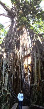
Cathedral Fig Tree and Curtain Fig Tree
The Cathedral and Curtain Fig Trees are huge
totally awesome trees and some of the best known attractions
on the Atherton Tableland. They are located just out of Yungaburra.
|
Cathedral Fig Tree |
Hot air ballooning
See the Atherton Tablelands from the air in a hot air balloon! The ultimate adventure!
Lake Barrine

Lake Barrine and the Teahouse in the foreground
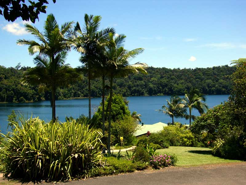
Lake Barrine is a beautiful freshwater lake close to Yungaburra.
The lake was formed 12- 17,000 years ago when a large volcano erupted,
leaving a large crater that over time filled up with water to create
a lake.
The crater was formed as a result of a series of volcanic explosions.
These explosions were caused by the hot molten rock coming into
contact with groundwater. This caused a buildup of steam, gases
and pressure which blasted the central core from the volcano. This
massive explosion left a huge crater, which filled with rain water
to create Lake Barrine.
The lake is 730 m above sea level, on average it is 65 m deep, it
is about 1 km in diameter, has a shoreline of almost 4.5 km and
is the largest of the natural volcanic lakes in the area. No streams
or springs feed the crystal clear lake; it is filled only by rainwater.
There is a 6 km. walking track around the lake and tour operators
offer cruises on the lake. You can swim here (croc-free) but watch
out for the boat and bear in mind the water can be rather cool.
The surrounding rainforest contains giant kauri , red cedar trees,
bumpy stin ash, flowering umbrella trees, and abundant wildlife
including water dragons, giant eels, sawshell turtles, scrub pythons,
black ducks, plumed whistling ducks, black coot, whistling kites,
brahminy kites, black kites, white breasted sea eagles and dusky
moorhens.
On the shore of the lake there is a family owned tea house that
does good food, coffee, tea etc. and also has a display of the infamous
stinging tree.
Lake Eacham
Lake Eacham is another popular lake of volcanic origin, not far
from lake Barrine, and was also formed years ago by molten magma.
This lake is the centre of the Crater Lakes National Park and is
fed by underground springs so it maintains a constant water level
and is unaffected by drought.
The local Ngadjon -jii Aboriginal people name this lake Wiinggina
Back in 1886 , Lake Eacham was included within original survey plans
sudividing the whole of the Lake Eacham area into farming blocks
but fortunately in 1888 the scenic value of the lake was recognised,
and both the lake and shoreline rainforest were formally proclaimed
scenic reserve and in 1934 the Qld Government declared the lake
and surrounds a National Park.
Lake Eacham is isolated from any other watercourse so how any fish
arrived there to begin with is a mystery, but somehow, the Lake
Eacham rainbowfish found its way into the volcanic lake. Unfortunately
for this small fish, other larger native fish were introduced into
this closed system and eventually, these larger fish ate the Lake
Eacham Rainbowfish into extinction.
Lake Eacham is the centerpiece of the 4.89 km² (1,210 acres)
, with a dense rainforest and thousands of small animals. It is
therefore a protected area under Queensland State legislation (Nature
Conservation Act 1994), and, as such, the natural and cultural resources
most closely associated with the Lake are protected and managed
by the Queensland National Parks and Wildlife Service.
The lake has an average depth of 65.5 metres (215 ft) and is considered
by locals as being ideal for swimming, canoeing, bushwalking, and
bird watching.. A large grassy area is terrific for picnics, sunbathing,
or just watching children as they play in the shallow water near
the edge of the lake. There is a 3 km. circuit walk around the lake
that takes around 45 minutes, this is highly recommended as there
are some awesome trees along this track.
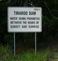
Tinaroo Dam
|
Tinaroo Dam, also locally known as Lake Tinaroo,
is a very popular recreation place for the locals and surrounded
by the Danbulla State Forest. It was completed in 1958 and
traps enough water from the Barron River to create a lake
3/4 the size of Sydney Harbour with over 200 kilometres of
shoreline. Each year, the lake is stocked with fresh baby "Barra" from the Walkamin Research Station because the fish are unable to breed due to the lack of access to salt water. Also found in Lake Tinaroo are eel-tailed catfish, sooty grunter, sleepy cod, mouth almighty, archer fish, spangled perch, long tom and many species of crayfish, including the red-claw and yabby. |
|
The Tinaroo Hydro Power Station became operational in May, 2004 and generates 1.6 megawatts, the dam is also used to regulate the waterflow for use at the Barron Gorge Power Station further downstreamand provides the water supply for many towns in the area such as Mareeba, Kuranda, and Yungaburra.
During some droughts in recent years water skiing became dangerous
as water levels dropped and trees that had gone under water when
the dam was filled once again saw the light of day.
The lake is surrounded by national park, rainforest, pine tree plantations
and Australian "bush". Hiking paths wind in and out of
the mountains surrounding the lake and range from a pleasant walk
from the parking lot to the water-front, to week long treks around
the lake and its mountains.
Undara Volcanic National Park
Undara Volcanic is a national park which is notable for its lava tubes and gem fossicking. Minerals found there include topaz, moonstone, peridot, aquamarine, garnet, quartz and gold. The park contains the remains of the Earth’s longest flow of lava originating from a single volcano.
Mount Hypipamee Crater and Dinner Falls - are located approx 23
km south west of Atherton on the Kennedy Highway.
The Mount Hypipamee Crater, also known as The Crater is a huge diatreme,located
south-east of Herberton on the Atherton Tableland in Far North Queensland,
Australia. It is 61 metres in diameter and 82 metres deep.
It was first discovered by accident when in 1879 Weate and party
nearly fell into it. They were heading towards the Mulgrave River
on a 5 month gold prospecting expedition. The national park was
established in 1908 under the sponsorship of Mr Ringrose of Herberton.
There was a debate at the “crater trust” meetings during
the 1930s as to what to call “the crater”, the "Herberton
Crater" was one suggestion but it was wisely decided to call
it the traditional Dyrbal name, Mount Hypipamee. A request was written
to the Reverend Gribble of Palm Island to find the origin of the
name. The name Hypipamee is a corruption of the Aboriginal word,
nabbanabbamee, which is connected with a legend of two young men
who cut down a sacred candlenut tree, only to be swallowed up by
a large hole in the earth the crater.
The water surface is covered with duck weed. In the past visitors
threw rocks down into the water to hear the loud bang when the rock
hits the surface of the water and the noise echos up the sides.
Dinner Falls at the head of the upper Barron River gorge is also
part of this park.
It was once thought that "The Crater", Lake Eacham and
Lake Barrine were all connected underground with water tunnels,
but this is incorrect. Local legend once said that an aboriginal
woman once fell over the side into the crater and later surfaced
in Lake Eacham.
About Cairns Highlands - Accommodation - Tours & what to do - Transport & car hire - Photos - Map
HOME PAGE
Tourist Information
General Information
And Entertainment
ACCOMMODATION IN AUSTRALIA
Bed
& Breakfast
Budget
Accommodation
Backpackers Hostels
Hotels
in Australia
CAR HIRE IN AUSTRALIA
Australia Rental Cars
And
Campervans


TOURS
IN AUSTRALIA
What To Do In Australia
On-line
Shopping
On-line
Dating
![]()
About
Australia
Visas For Australia
How
To Get To Australia
How To Get Around
Travel Insurance
Travel Guides
Working
In Australia
Australian
Posters
Survival
Tips
Weather,
When To Go

Use of
this website constitutes acceptance of the User Agreement for this website
Contact us |
Advertise on this site
| Link to this site |Add
your photos or stories to this site |
Webmasters | Affiliates